

Dettifoss
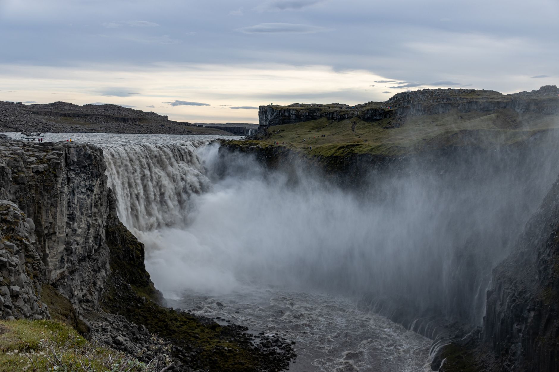
Dettifoss is a hundred metres of glacial river dropping forty-four into the Jökulsárgljúfur canyon, the north's anchor and the waterfall that makes the ground vibrate, twenty-four kilometres off Route 1 on a paved road. Two hours for the west bank, five for both, and free at either car park.
Dettifoss in a nutshell
Dettifoss: what to expect
What you read here rests on 72,000+ planned stops in Iceland on Stippl.
Two hours at Dettifoss is the west bank, and five is the whole canyon. The ground vibrates through the rock near the falls, which is the one thing every visitor reports, the west platforms give the straight-on view across the full width at the end of a kilometre of gravel, the east bank puts you at the lip itself and is the only side from which Selfoss's whole horseshoe reads, Selfoss a kilometre upstream is ten metres high and far wider than tall, and Hafragilsfoss opens the canyon out where almost nobody goes. 78.74% of stops here on Stippl are a pass-through.
A trip that carries Dettifoss is a maximal one, and the pass-through share here is the highest in the country. 99.0% of the trips carrying it on Stippl carry six or more Icelandic stops, which is the whole ring rather than a corner of it, it opens only 0.8% of the trips it appears on, of everyone who plans it on Stippl, and it holds 0.81% of every Icelandic stop, because the detour is the price.
Drive the paved west road from Route 1, start early from a Mývatn bed to beat the coaches, stay on the marked paths as a geology instruction rather than a courtesy, and take the east bank only in high summer with a capable car. Skip the hollow beside the falls, which closed permanently after a landslide, and skip the west platforms with an unprotected lens, because the spray takes it.
Plan Dettifoss in Stippl
Day-by-day planning, stays and budget in one app, with every place from this guide already on the map.
Download the appWho Dettifoss is for
First-timers doing the ring
The north's anchor and the reason the Diamond Circle exists as a route, and the west bank asks nothing more than a paved detour.
Travellers who want scale
Dettifoss is power and Selfoss is beauty, and plenty of people prefer the smaller one a kilometre upstream.
Confident summer walkers
The east bank, the loop to Selfoss and the descent to Hafragilsfoss are a genuine half day of rough ground with no rails.
East-bank photographers
The west takes the spray and a lens does not survive it, and the east is dry by comparison with the lip in the frame.
Maximal-loop drivers
99.0% of the Stippl trips carrying Dettifoss carry six or more Icelandic stops, the whole ring rather than a corner.
Pass-through planners
78.74% of Stippl stops here are no night at all, the highest share in Iceland, because the nearest beds are an hour away.
Maybe not for you: people in a hurry, because it is twenty-four to thirty-two kilometres each way off the Ring Road; and small children, since the canyon edges are unfenced and the rock is wet, and the warden's own view is that the visitors are the risk.
The best time to visit Dettifoss
Summer
June to September
Both banks open, the east road passable, the park staff on the east bank almost daily and the coaches on the west from mid-morning.
The shoulders
May and October
The west road usually open and the east road closed or marginal, the spray freezing on the platforms by October and the canyon at its emptiest.
Winter
November to April
Partial winter service on the west road, the east road closed roughly October to late May, crampons on the path and the super-jeep tours from Mývatn as the reliable route.
Glacial melt
July and August
The Jökulsá á Fjöllum at its fullest off the ice cap, the spray at its widest and the vibration at its strongest underfoot.
- 78.74% of stops at Dettifoss on Stippl are a pass-through, the highest share in Iceland. Two hours for the west bank from Route 1 and back, and the bed at Mývatn an hour away.
- 99.0% of the trips carrying Dettifoss on Stippl carry six or more Icelandic stops. The falls are a marker of the whole ring, and the detour is planned into the north rather than added on the day.
- The west road is paved end to end, and newer than most of the guidance about it. The southern section was finished in 2012 and the through route only in November 2021, which is why older descriptions still say gravel.
- The east road closes for half the year. Roughly October to late May, gravel, with a small car park and an unfenced rim, so the east bank is a high-summer choice with a capable car.
- The hollow beside the falls is closed for good. The park shut Fosshvammur on the west bank permanently in May 2026 after a landslide and an expert survey, so the descent next to the water no longer exists.
- There is no bus. The national network lists no route to Dettifoss, Ásbyrgi or along either road, and the day tours from Akureyri, Mývatn and Húsavík are the only way without a car.
Add your Dettifoss dates and we'll flag the weather
Stippl shows the season, crowds and prices for every stop on your route.
Describe your trip, get a Dettifoss itinerary in seconds
Everything in this guide is already in Stippl. Tell the planner how long you have and what you like: it builds the route, the days and the travel times, and you edit whatever you want.
Things to do at Dettifoss
Standing where the ground vibrates
The closest thing to a universal report, and it is a physical sensation through the rock near the falls rather than a view.
The head-on view from the west
The straight-on line across the full width from the west platforms, reached on a kilometre of gravel path, in the spray.
The lip from the east bank
The east side puts you at the edge of the falls themselves, and it is the only bank from which the whole horseshoe of Selfoss reads.
Selfoss upstream
A kilometre south, ten metres high and far wider than tall, and by many accounts the better of the two.
The empty rim at Hafragilsfoss
The canyon opens out two and a half kilometres north and almost nobody is there, because most visitors turned back.
The two-day canyon trail
Thirty-two kilometres through Jökulsárgljúfur from Ásbyrgi with a night at Vesturdalur, absent from every guide and the park's own long walk.
The areas of Dettifoss
The west bank
The all-season side
Paved road, coach-served and wet with spray, with the head-on view across the full width at the end of a kilometre of gravel path. For everyone, and the only realistic choice outside summer.
The head-on view in any season, but the spray takes the lens and the coaches take the platform.
The east bank
The lip
A gravel approach, a small car park and an unfenced rim, with the falls at your feet and the only view of the whole of Selfoss. For confident summer walkers with a capable car.
Standing at the lip and the whole of Selfoss, though the road closes half the year.
Upstream to Selfoss
The wider fall
A kilometre south on the trail, ten metres high and far wider than tall, with the horseshoe reading best from the east. For anyone with a spare hour and boots.
The prettier fall by several accounts, and an hour of rough ground to reach it.
Downstream to Hafragilsfoss
The empty rim
A rest area on the east rim two and a half kilometres north, where the canyon opens out and the crowd has turned back. For those who did not turn back.
The canyon with nobody in it, but a walk most people do not make.
Ásbyrgi and Vesturdalur
The park's services
The horseshoe canyon and the basalt whorls to the north, with the only food, fuel, beds and visitor centre in this part of the park. For a second half day, or the trail's far end.
The only food, fuel and beds in the park, and an hour from the falls.
See every Dettifoss neighbourhood on one map
Save the areas you like and Stippl plots your days so you're not crossing the city twice.
Where to stay at Dettifoss
Mývatn is the default base and an early start from it is the standard advice, close enough to reach the falls before the coaches, with Ásbyrgi's campsite and guesthouses to the north as the alternative for anyone walking the canyon. 78.74% of stops here on Stippl are a pass-through, the highest share in the country, because there is nowhere at the falls to sleep.
The west bank
No beds at the car park; Mývatn's rooms are an hour away, €130 to €300 a night.
The east bank
Nothing on the rim; the same Mývatn beds are the nearest, €130 to €300 a night.
Upstream to Selfoss
No rooms on the trail; the park's campsites are the closest tents, about €15 a person.
Downstream to Hafragilsfoss
The rest area only; Ásbyrgi's beds are an hour north, €100 to €200 a night.
Ásbyrgi and Vesturdalur
The park campsite and the guesthouses at Ásbyrgi, €15 to €200 a night.

Dettifoss customs and what not to do
Paths are a geology instruction
The park closed an entire viewing area after a survey found fractures that make no distinction between rock and visitor, so the marked path is the whole rulebook.
The ground is being restored
Vegetation restoration is planned where visitors trampled the hollow, and the moss around the falls takes decades to regrow.
The visitors are the risk
The north-area park warden's own view is that the greater danger at the site comes from unprepared people on slippery ground, not from the falls.
Private land, managed
The falls sit on privately owned land under a management agreement rather than public wilderness, and the arrangement is why the paths are where they are.
Take everything out
There is no shop and no bin service beyond the summer staffing, and the east bank sees park staff almost daily only in the three summer months.
The superlative is precise
Most powerful in Europe by power rather than by volume, where it is not even first in Iceland, and the locals know the difference.
Do
- Start early from a Mývatn bed
- Drive the paved west road from Route 1
- Take the east bank only in high summer with a capable car
- Bag the camera on the west platforms
- Walk on to Selfoss if the boots and the hour allow
Don't
- Step off the marked paths anywhere near the rim
- Look for the hollow beside the falls; it is closed for good
- Trust the map app to the paved bank
- Take the east road outside summer
- Leave anything behind; there is no bin
What a Dettifoss visit costs
The stop
€0
Both car parks, both banks and every path; the cost is fuel and hours.
With a Mývatn night
€130–240
A bed an hour away and the falls before the coaches.
The guided day
€170–250
A Diamond Circle or small-group tour from Akureyri, Mývatn or Húsavík.
Track what you actually spend
Set a daily budget per country and log expenses in any currency while you travel.
Fun facts about Dettifoss
Dettifoss retreats south at roughly 50 centimetres a year. The falls retreat south as the lip erodes, and the canyon behind them is the record of where they used to be.
Dettifoss is the most powerful waterfall in Europe by power, not by volume. By water volume the Rhine Falls is larger and so is Urriðafoss in Iceland, and the park states the distinction flatly.
The on-site sign at Dettifoss propagates the disputed claim. Which is one reason the superlative travels unchecked into every derivative article, and the university's own figures are the correction.
The road to Dettifoss is younger than most of the writing about it. Road 862 was only completed as a through route in November 2021, which is why older guides still describe gravel.
The canyon below Dettifoss is 25 kilometres long and over 100 metres deep in places. It narrows to about a hundred metres across for a stretch just north of the falls, half a kilometre wide elsewhere.
99.0% of the Stippl trips carrying Dettifoss carry six or more Icelandic stops. The falls are the marker of a maximal trip, and almost nobody detours here on a short one.
Local tips for Dettifoss
No bus, and that is a finding
The national network lists no route to Dettifoss, Ásbyrgi or along either road, so the day tours from Akureyri, Mývatn and Húsavík are the only carless way.
Road 862 is paved end to end
From Route 1 at Mývatnsöræfi to Route 85 in Kelduhverfi, the west approach is asphalt the whole way.
The road outdates the guides
The southern section was finished in 2012 and the through route in November 2021, which is why older descriptions still warn of gravel.
Fosshvammur is closed for good
The park shut the hollow beside the falls on the west bank to all traffic in May 2026 after an expert survey, and the guidebooks have not caught up.
It followed a landslide
A slide fell right by the west viewing platform in June 2025, the scar was still unstable on inspection and new cracks had appeared, so the closure is not a theory.
A pass-through, on a full ring
78.74% of Stippl stops here are no night at all and 99.0% of the trips carrying the falls carry six or more Icelandic stops, because the detour belongs to the whole loop.
Dettifoss questions, answered
West if you want it easy, all-season and head-on, on the paved road with the spray in your face. East if it is high summer, you have a capable vehicle and you want to stand at the lip and see the whole of Selfoss upstream. 78.74% of stops here on Stippl are a pass-through either way, the highest share in Iceland.
No. The hollow beside the falls on the west bank, Fosshvammur, closed permanently after a landslide beside the viewing platform and a survey that found fresh cracks, and the marked paths above it are the whole visit now. The guidebooks have mostly not caught up, so the closure is the thing to know before the drive.
Yes, at either car park: the park's fee list covers Skaftafell and Jökulsárlón only, and the toilets carry no charge either. The cost is the fuel and the hours, twenty-four kilometres each way off Route 1 for the west bank, and Dettifoss holds only 0.81% of Icelandic stops on Stippl because of it.
Not on scheduled transport, because there is no bus to the falls, to Ásbyrgi or along either road. The day tours from Akureyri, Mývatn and Húsavík are the carless way, and only 0.8% of the trips through Dettifoss start here, of everyone who plans it on Stippl, since the falls are reached from the ring rather than the airport.
The west road has partial winter service and the east road is closed roughly October to late May, so the winter visit is the west bank with crampons on the path or a super-jeep tour from Mývatn. Put the falls into Stippl as a morning from the lake, then ask people who went in the cold in subreddits like r/VisitingIceland whether the road held.
By power, that is the park's claim and the sign repeats it; by water volume the Rhine Falls is larger and so is Urriðafoss in Iceland, and the distinction is real. 99.0% of the trips carrying Dettifoss on Stippl carry six or more Icelandic stops, so the people who see it have usually seen Gullfoss first and can compare.
Every guide is written by the Stippl editors and checked against the trips our travellers actually plan. Spotted something out of date? Let us know.
Plan Dettifoss in Stippl
Day-by-day planning, stays and budget in one app, with every place from this guide already on the map.
Download the app