

Koh Chang
Koh Chang spreads the same visitors over far more coast than the famous islands, and people give it the longest stays of any island in Thailand. Waterfalls, mangroves, and a mountain interior that is all national park.
Koh Chang in a nutshell
Koh Chang: what to expect
Our own data here is 1,756,000+ stops planned across Thailand on Stippl.
Koh Chang is Thailand's second-largest island and roughly four-fifths of it is protected park, which makes for a different kind of island week. The west coast holds the beaches and the sunsets at Klong Prao and Kai Bae, Bang Bao is an old fishing village on stilts over the water and now the pier the dive boats leave from, and Klong Plu waterfall is a short walk behind the coast to a pool you swim in. Most travellers give the island 4 nights on Stippl.
Koh Chang holds people longer than almost anywhere else in Thailand, and the journey is part of why. Only 14.2% of Koh Chang stops planned on Stippl are a single night, against a country that mostly moves on every three days. Getting here takes six or seven hours from Bangkok by minibus and ferry, so nobody arrives for one night by accident.
Four nights is the shape and a week is not excessive. Base yourself on the west coast for the sunsets, then cross to the east for Salak Khok's fishing village, the Ao Ka Rang viewpoint and the mangroves, which almost nobody bothers with. Take a scooter or a shared songthaew, because you cannot hail a taxi and the island is far bigger than it looks. Dive or snorkel in the marine park around it, and if the days allow, hop south to Koh Mak and Koh Kood, which is the natural extension rather than a separate trip.
Plan Koh Chang in Stippl
Day-by-day planning, stays and budget in one app, with every place from this guide already on the map.
Download the appWho Koh Chang is for
Travellers heading to Cambodia
Koh Chang is the natural last Thai stop before the Trat border, and it turns up mostly inside those routes.
Anyone avoiding the crowd
The size is the point: the same visitor numbers spread over a far larger coastline than the famous islands.
Families
A spread of quiet beaches, a waterfall walk short enough for children, and the longest typical stays on Stippl anywhere in Thailand at 4 nights.
Nature-first beach travellers
Waterfalls, mangroves and a mountainous protected interior, rather than nightlife and boat tours.
Social travellers, in one place
Lonely Beach is the island's concentrated version of a scene, and it stays contained rather than spreading island-wide.
Maybe not for you: anyone on a west-coast island route, since it is on the wrong side of the country; travellers without a scooter licence who dislike depending on taxis; and casual island-hoppers, because the connections here are to Koh Mak and Koh Kood, not the famous islands.
The best time to visit Koh Chang
Dry
November to April
The Gulf east-coast season: calm water, every boat running, and the busiest and priciest window.
Wet
May to October
Rain and a rougher sea, but the interior at its best, with the Klong Plu waterfall at its finest from July to September. Some businesses reduce hours; the island does not empty.
- Koh Chang runs on the Gulf calendar, not the Andaman one. It is a wet-season alternative to the west coast rather than a competitor to it: when Phuket is under the monsoon, this side is the drier sea.
- The waterfall is best when the beaches are worst. Klong Plu at full flow is a July to September sight, and the interior walks are green then; the sand belongs to the dry months.
- The island-chain hop to Koh Mak and Koh Kood thins out from mid May to mid October. The speedboats south are withdrawn in the low season, so a three-island trip is a dry-season plan.
Add your Koh Chang dates and we'll flag the weather
Stippl shows the season, crowds and prices for every stop on your route.
Describe your trip, get a Koh Chang itinerary in seconds
Everything in this guide is already in Stippl. Tell the planner how long you have and what you like: it builds the route, the days and the travel times, and you edit whatever you want.
Things to do in Koh Chang
 Photo by Christophe95 via Wikimedia
 Photo by Alin Meceanu via Unsplash
Klong Plu waterfall
Walk fifteen minutes behind Klong Prao to the tiered fall with a swimming pool at its foot, about €5 park entry. The island's one universally named sight, and at its best in the wet months when most visitors are not there.
The east-coast loop
Ride to Salak Khok's fishing village, the Ao Ka Rang viewpoint and the mangrove side of the island, which almost nobody crosses to. A scooter day with lunch at the stilt restaurants over the water.
Bang Bao stilt village
Walk the old fishing settlement built over the water at the southern tip, now the departure pier for the dive and island boats and a strip of seafood restaurants. Free, and best at the end of the afternoon when the boats come back.
Diving in Mu Ko Chang National Park
Dive the marine park around the island, the reason the dive shops are here: soft coral at Hin Luk Bat and the HTMS Chang wreck for the advanced. Two dives run about €70 from Bang Bao.
Sunset from Klong Prao or Kai Bae
Sit on the west coast at the end of the day, where the beaches face the right way and the offshore islands give the sunset something to sit against. Free, and the beach bars pour from five.
Koh Mak and Koh Kood
Take the speedboat south to the two smaller, quieter islands, the natural extension of a Koh Chang trip; Koh Mak is forty minutes and Koh Kood ninety, about €15 and €25. Book the boat a day ahead in high season.
The neighbourhoods of Koh Chang
White Sand Beach
The busiest beach, the centre
The main beach in the north-west: resorts, restaurants and the closest thing the island has to a centre, with the best sand for swimming. For first visits and anyone who wants everything on foot.
Restaurants and the beach together, and the highest prices on the island.
Klong Prao
Long, quiet, waterfall behind
The long middle beach, quieter than White Sand and a short ride from it, with the Klong Plu waterfall trailhead behind. For couples and families who want space and a resort with a pool.
Space and a calm beach, and a songthaew for the evening out.
Kai Bae
Family sand, island sunsets
Further south, family-leaning, with the small islands offshore that give it the sunsets and a cluster of restaurants on the road. For families and for a mid-priced bungalow near the water.
Sunsets over the islands, and a beach that shrinks at high tide.
Lonely Beach
Backpacker bars, bad road
The backpacker and nightlife beach in the south-west, reached over the island's worst stretch of road and loud until late. For backpackers and anyone who came for the bars.
The cheapest beds and the best night out, and the road home in the dark.
Bang Bao
Stilt village, dive boats
The old stilt fishing village turned pier and seafood strip at the south-west end, where the dive and island-hop boats leave. For divers and for a night among the boats.
Every boat at the door and the seafood, and no beach to lie on.
See every Koh Chang neighbourhood on one map
Save the areas you like and Stippl plots your days so you're not crossing the city twice.
Where to stay in Koh Chang
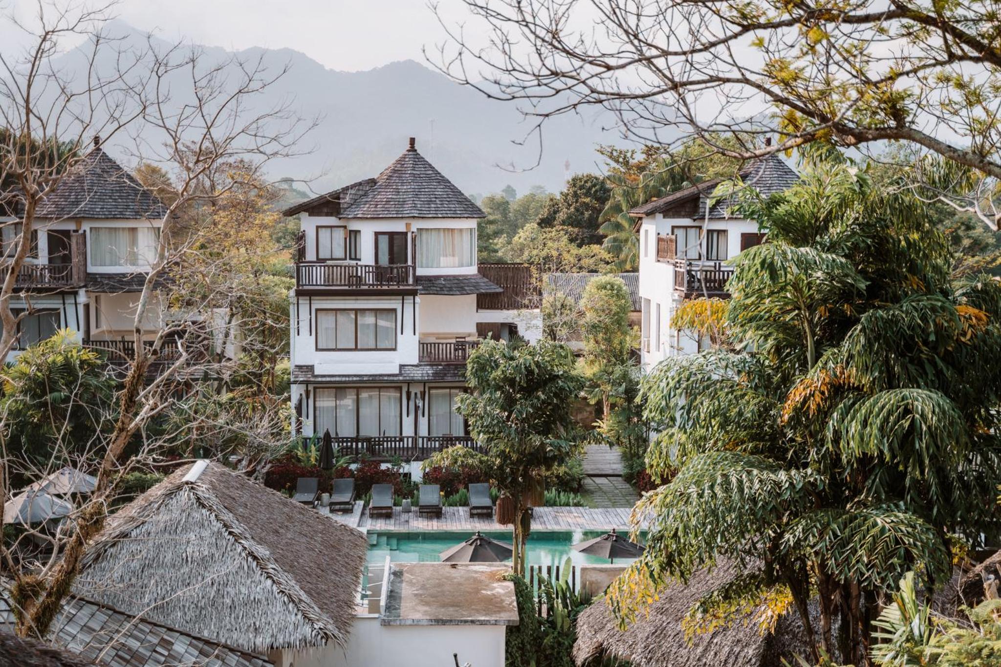
Stay on White Sand Beach for a first visit: it has the restaurants, the services and the best swimming sand, and a room in the middle of the strip puts some of the trip on foot. Most people give Koh Chang 4 nights on Stippl, longer than most Thai islands get. The east coast is a day-trip side with almost no rooms, so keep to the west.
White Sand Beach
Beachfront resorts and mid-range hotels, €40 to €120, with the family rooms in hostels from €25.
Klong Prao
Quieter resorts with pools and a few homestays behind the beach, €35 to €100.
Kai Bae
Family-run bungalows and small resorts on the road and the sand, €25 to €80.
Lonely Beach
Hostels and cheap bungalows, dorms €6 to €12 and huts €12 to €30, with music until late.
Bang Bao
Stilt guesthouses and a couple of resorts on the pier, €25 to €70, handy for an early boat.


What to eat in Koh Chang
The stilt-village catch, grilled whole
Green papaya salad, pounded to order
The national noodle benchmark
Coconut-based, hotter than central Thai
Discover food spots in Stippl
Find restaurants and markets on the map, save them to your itinerary, works offline too.
Koh Chang customs and what not to do
The east coast is villages
Fishing villages where visitors are unusual, so it is village etiquette: a greeting, a shirt on, and a nod before a photograph of anyone or their boat.
The shrine is in use
Chao Por Koh Chang serves islanders and boat crews and is a place of practice, not a viewpoint; go quietly and leave the offerings alone.
The name means elephant
The island's logging history is elephant-related, which is why elephant camps operate here; the national no-riding rule applies, whatever the camp calls itself.
Bang Bao is a working pier
The stilt village sells to visitors and still lands fish; do not block the walkway for photos and keep off the private jetties behind the shops.
Do
- Book a room near the middle of the west strip if you would rather walk than ride
- Cross to the east coast at least once; it is a different island
- Check the last ferry before planning the mainland leg
- Read Safety before renting a scooter
Don't
- Judge the distances from the map
- Assume you can hail a taxi
- Plan onward hops to Samui or Phangan from here
- Ride the Kai Bae to Bang Bao road in the wet
What a Koh Chang trip costs
Budget
€20–30
Hostel or bungalow at Lonely Beach, local food, a shared scooter.
Mid-range
€50–80
Beach resort room, restaurant meals, own scooter, a dive or boat day.
High-end
€120+
The west-coast resorts, private transfers.
Track what you actually spend
Set a daily budget per country and log expenses in any currency while you travel.
Fun facts about Koh Chang
The name Koh Chang means Elephant Island. The name comes from the island's shape and from the elephants historically used for logging its mountainous interior.
Around 80% of the island is protected national park. Mu Ko Chang National Park covers the forested interior, which is the structural reason all the development sits on one coastal strip.
Cambodia is visible from the east coast, about 6 km away. The sea border runs just off the island, which is why Koh Chang turns up on routes that cross into Cambodia rather than down the west coast.
Koh Chang is Thailand's second-largest island after Phuket. The map makes it look small, and exploring it properly is a full day's driving rather than an afternoon's.
The island belongs to a different weather system from the Andaman coast. The eastern Gulf has its wet season from May to October, so Koh Chang is dry when Phuket is not, and the reverse.
Bang Bao is a village built entirely on stilts over the sea. The fishing settlement at the southern tip is one long wooden pier of houses, shops and restaurants, and the dive boats leave from the end of it.
Local tips for Koh Chang
You cannot hail transport
There are no cruising taxis or tuk-tuks. Transport meets the pier and runs to the hotels; after that it is the shared songthaews, €1.50 to the north and €3 to Lonely Beach, or a scooter.
The ferry sets the schedule
It runs hourly, in daylight only, and the last one is early evening. Plan the Bangkok leg backwards from it; a late bus means a night in Trat.
Onward means Mak and Kood
The two smaller islands south are the natural next stops. Reaching Samui or Phangan from here means going back through the mainland, a full day.
How long to stay
Most people give Koh Chang 4 nights on Stippl, longer than most Thai islands, because the beaches are strung along one west-coast road and each is a day.
The road is the danger
You will pass a fresh scooter crash on any day you ride the island's length; the Kai Bae hill and the Lonely Beach run are the worst, with sand on the bends. Take the songthaew.
Rentals hold your passport here
The shops normally keep a passport or ID as security and rarely accept a photocopy now, because of damage disputes. Photograph the bike before you leave and insist on the copy.
Koh Chang questions, answered
It costs a day. Six to seven hours from Bangkok by minibus and ferry, or a flight to Trat and a transfer, and there is no shortcut around it. Lay that travel day into the route in Stippl rather than pretending it is a morning. Then ask people who have made the trip, in subreddits like r/ThailandTourism.
Because getting there costs a day and the island is bigger than it looks. The longest stays run to 7 nights on Stippl, and about four-fifths of the island is protected park, so there is more to ride to than a strip of beach. The east coast alone takes a full day.
November to April, which is the Gulf's east-coast season and the opposite of the Andaman's. 73.3% of the trips that include Koh Chang on Stippl start inside those months. Klong Plu waterfall is the exception, since it is at its best when there has been rain.
It is Thailand's second-largest island, and the practical version of that is that you cannot walk between beaches and cannot hail a taxi. A rented scooter or a shared songthaew is how everyone moves around. About four-fifths of it is national park, most of that forested interior rather than coast.
If the days allow, yes, because they are the natural extension rather than a separate trip. Both sit south of Koh Chang in the same island chain, both are quieter, and Koh Kood in particular is bigger and emptier. Boats run between them in the high season and thin out sharply outside it.
The length of stay says so. 0.59% of Thai stops planned on Stippl are on Koh Chang, a small share for the country's second-biggest island, and the people who do go stay longer than almost anywhere else in the country.
Every guide is written by the Stippl editors and checked against the trips our travellers actually plan. Spotted something out of date? Let us know.

Plan Koh Chang in Stippl
Day-by-day planning, stays and budget in one app, with every place from this guide already on the map.
Download the app