

Uvita
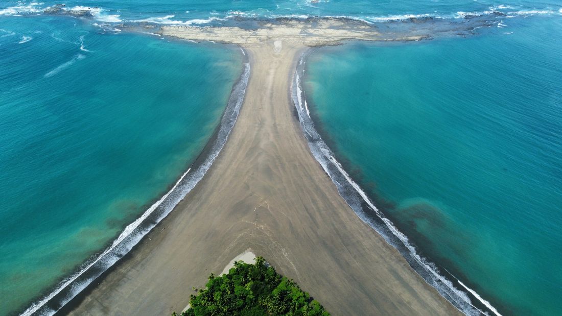
There is a sandbar here shaped like a whale's tail, in the bay where humpbacks come to breed. Two separate populations breed at opposite ends of the year, which gives the town two high seasons.
Uvita in a nutshell
Uvita: what to expect
We counted 87,000+ planned stops across Costa Rica on Stippl before writing this.
Uvita is where the whale tail is, and it only exists at low tide. The tómbolo is a natural rock-and-sand fluke about six hundred metres across, a twenty-minute walk from the entrance, and at high tide there is nothing to see. Marino Ballena was the first marine park in Central America created purely for what lives in the water, and two separate humpback populations breed here at opposite ends of the year. Nauyaca falls in two tiers an hour inland, and Catarata Uvita is half an hour on foot from the main street.
Uvita is the door to the Osa Peninsula, and it is a stronger door than the capital is to anything. Trips that carry Uvita are three times more likely to carry Drake Bay than Costa Rican trips in general, the largest single relationship we measure in the country. They are also the longest itineraries here, and the ones most likely to stay inside Costa Rica from beginning to end.
Check the tide table before you walk out to the tail, and 2 nights gives you room to. August and February are the two whale windows and both show up in the plans, while September and October sit inside a window and lose to the rain. You will want a car, because the waterfalls, the beaches and the Sierpe boats all need one. Do not come for a night out: the evening here is dinner and bed.
Plan Uvita in Stippl
Day-by-day planning, stays and budget in one app, with every place from this guide already on the map.
Download the appWho Uvita is for
Anyone bound for the Osa
Uvita is the last ordinary town before Sierpe and the Drake Bay boat, and most people give it 2 nights on the way.
Whale watchers
Humpbacks pass in two windows a year, and the bay is one of the most reliable places on the coast to see them.
Waterfall travellers
Nauyaca, Catarata Uvita and El Pavón are all within an hour, and Nauyaca alone is worth the drive.
Anyone wanting a quiet Pacific
Uvita is Manuel Antonio's coast without Manuel Antonio's crowds, and the comparison holds every time.
Maybe not for you: anyone wanting nightlife, since the evening is dinner and bed; and anyone without transport, because the waterfalls, the beaches and Sierpe all need a car or a tour.
The best time to visit Uvita
Dry season
Mid December to mid April
Hot, busy over Christmas and Easter, and inside the first whale window. The park's own words for when the rains stop, and the road south from Quepos at its best.
Green season
Mid April to mid December
Dry mornings, an afternoon shower and the waterfalls at full flow, with the second whale window from late July to October. October is the wettest month anywhere we cover, and the town is empty in it.
- January is the month most travellers plan Costa Rica for on Stippl, and Uvita is planned about 80 days ahead, one of the longest leads of the ten we cover. The whale tours and the small lodges are what set it; the town has no hotel of size.
- Whale season one and whale season two do not have the same weather. The humpbacks are in the bay from December to mid March in the dry and again from late July to October in the rain; the second window has more whales and fewer people.
- The green season is the better season for what people come for. Whales in the water, waterfalls running, the town empty and a pattern of dry mornings and an afternoon shower; the dry season has the sun and the Christmas crowd.
- The Whale's Tail at Marino Ballena only shows at low tide. The sandbar in the shape of a tail is walkable for an hour or two either side of low water; the tide table decides the day, not the weather.
Add your Uvita dates and we'll flag the weather
Stippl shows the season, crowds and prices for every stop on your route.
Describe your trip, get a Uvita itinerary in seconds
Everything in this guide is already in Stippl. Tell the planner how long you have and what you like: it builds the route, the days and the travel times, and you edit whatever you want.
Things to do in Uvita
 Photo by Luis Desiro via Unsplash
The whale tail at low tide
Walk out on the tómbolo as the sea pulls back, about €6 park entry; at high tide there is nothing to see. Check the tide table at the entrance before you set out, and two hours either side of low water is the window.
A whale-watching boat
Take the boat in either window, December to March or late July to October, about €70; the largest operator says plainly it cannot guarantee a sighting, which is the right answer. Mornings have the flatter sea.
Nauyaca Waterfalls
Walk four kilometres, take the four-wheel-drive transfer or ride a horse to the two falls on separate levels with pools beneath, about €10 to €35. The most beautiful waterfall in Costa Rica by most accounts; go early.
Catarata Uvita
Walk half an hour from the main street to the small waterfall with a natural slide and pools in town, about €4. The afternoon swim.
Playa Ventanas
Walk into the sea caves at low tide on the beach south of town, free with a small parking fee. Check the tide; at high water the caves are the sea.
A Sierpe mangrove tour
Take the boat fifty minutes south for three hours through the protected wetland with crocodiles, macaws and sloths, about €60. The morning departure has the birds.
The neighbourhoods of Uvita
The beach side
Park gate, restaurants
Between the highway and the park entrance: the beach, the park gate, most of the restaurants and the more expensive beds. For first visits and for the whale tail on foot at low tide.
The gate and the sand on foot, and the highest prices in town.
Upper town
Cheaper, greener, the waterfall
East of the highway toward the Uvita waterfall: cheaper, greener and a walk or a taxi from the sand, with the natural slide and the pools half an hour on foot. For budget travellers and the waterfall.
Cheaper and the waterfall, and a walk to the beach.
The ridge
Jungle lodges, view restaurants
The hillsides above town where the jungle lodges and the view restaurants sit, reached by car or a steep walk. For couples and for the bay from the terrace.
The best view on the coast, and a car for everything.
Ojochal
Village, restaurants, expats
The village fifteen minutes south along the coast with the surprising restaurant scene, the expat community and villas in the hills. For foodies and for long stays with a car.
The best dinners on the coast, and a drive for the park.
See every Uvita neighbourhood on one map
Save the areas you like and Stippl plots your days so you're not crossing the city twice.
Where to stay in Uvita
Stay on the beach side for a first visit, between the highway and the park gate, with the whale's tail and most of the restaurants on foot; the ridge above town is for the view and the price. Most people give Uvita 2 nights on Stippl, and three is better if the waterfalls are on the list. Camping is one of the cheaper ways to sleep near the park.
The beach side
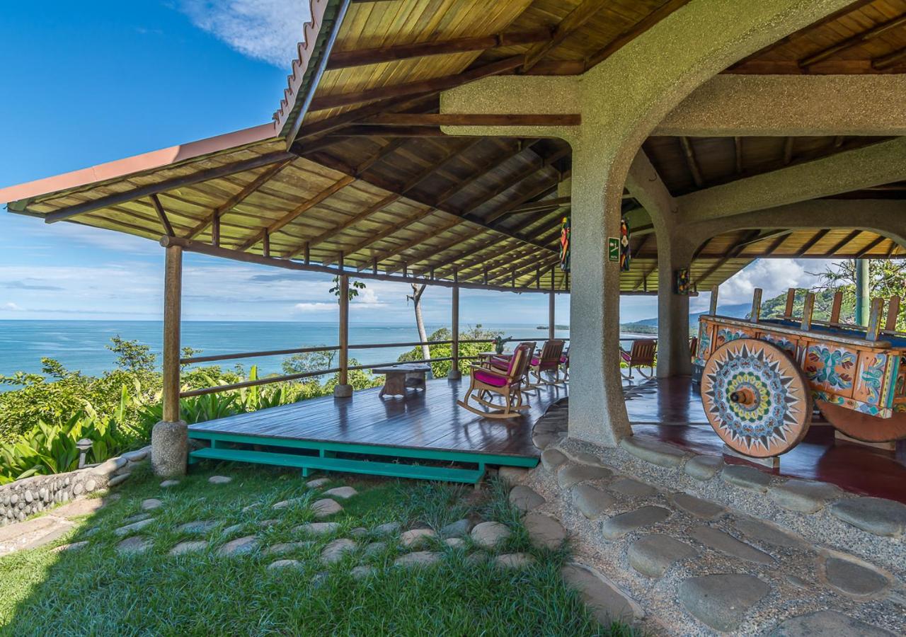
Cabinas and small hotels near the park gate, €60 to €150, and the beachfront places from €180.
Upper town
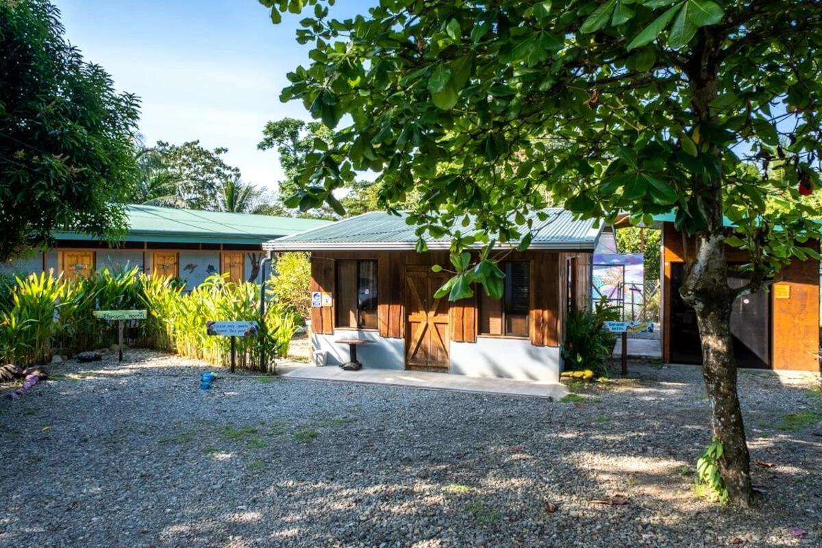
Hostels from €15 a bed and cheaper guesthouses, €40 to €80, a walk or a taxi from the sand.
The ridge
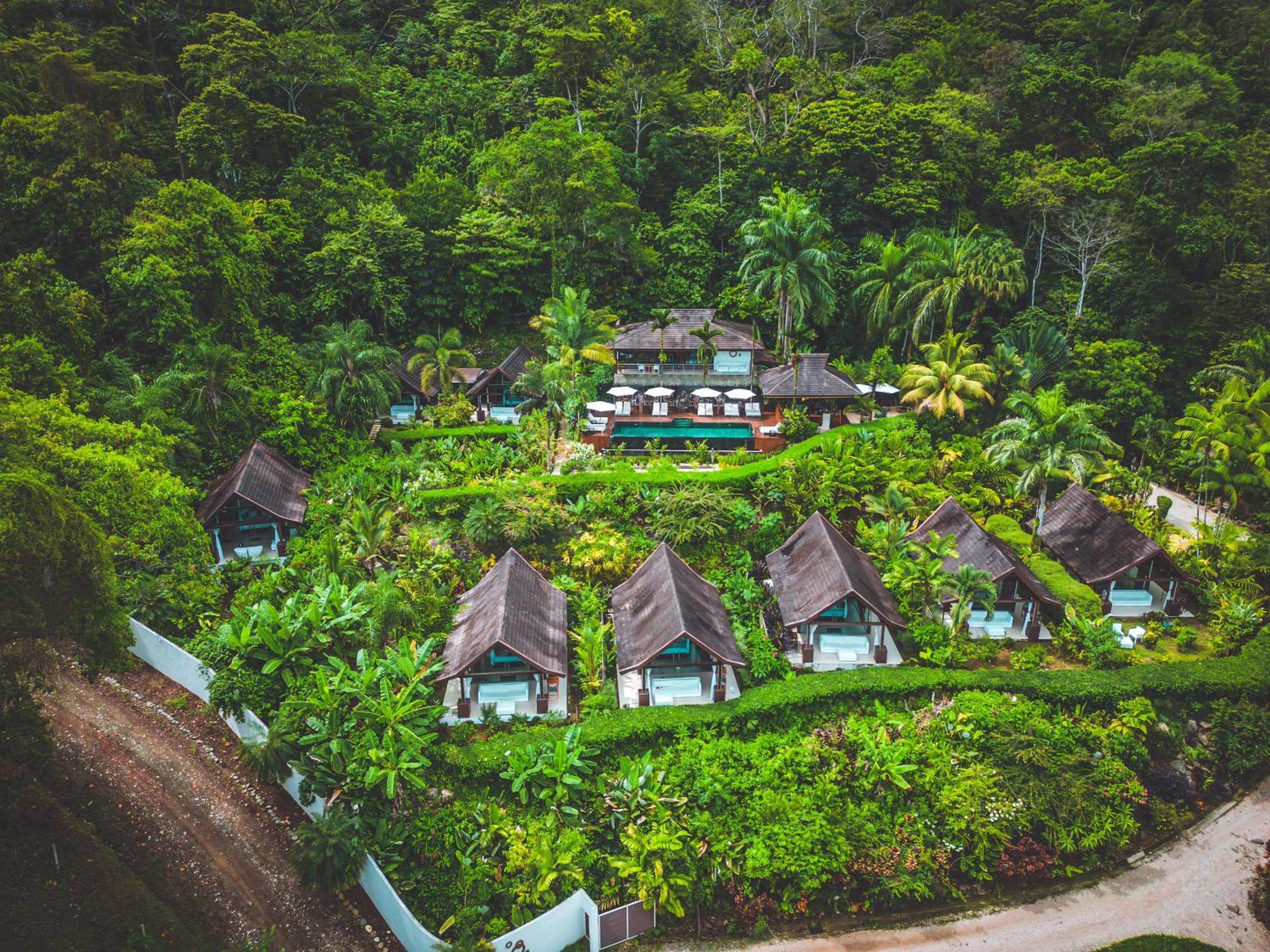
Jungle lodges, glamping tents and adults-only design villas, €120 to €500, reached by car.
Ojochal
Villas in the hills and small hotels among the restaurants, €80 to €200, fifteen minutes south.


What to eat in Uvita
Bowls, burgers and healthy plates, the most-named restaurant in town
Pizza, an address people go back to
Empanadas and pizza
Italian food up the hill with an ocean view; toucans and howler monkeys reported from the tables
Baking
Discover food spots in Stippl
Find restaurants and markets on the map, save them to your itinerary, works offline too.
Uvita customs and what not to do
This is the Costa Ballena
Uvita, Dominical and Ojochal market themselves as one region and the whale is the emblem; the September festival is the town's, and the parade is on the main road.
The park was a first
Marino Ballena was the country's first protected area created solely for marine life; the entry fee funds the rangers, and the whale-watching boats are licensed by it.
Check the horses first
One or two operators run tired animals; look at the horses before you pay, and choose the one that rests them and rides in the early morning.
The whale tail is tidal
The sandbar walk is the park's signature and the ranger at the gate tells you the turn time; going out when the water is coming in is what they warn about most.
Do
- Check the tide table before the whale tail walk
- Book a licensed boat for whale season, August to October
- Look at the horses before you book
- Carry cash for the park gate
Don't
- Walk the whale tail on a rising tide
- Approach the whales with an unlicensed boat
- Swim off the open beaches; the park beach is the calm one
- Drive down from San José on a Friday afternoon
What a Uvita trip costs
Budget
€47–75
Camping, hostel bed or basic cabina, sodas for most meals, one paid activity every other day.
Mid-range
€105–170
Beach-side or upper-town double, a share of a rental car, a paid waterfall or whale-watching tour and restaurant dinners.
High-end
€300+
Ridge design property such as Oxygen Jungle Villas or Kura Design Villas, private guides, private transfers.
Track what you actually spend
Set a daily budget per country and log expenses in any currency while you travel.
Fun facts about Uvita
Marino Ballena was the first marine park in Central America. Created by decree in 1992, it was the first protected area on the isthmus established purely for what lives in the water.
A sandbar shaped like a whale's tail sits in the bay where humpbacks breed. The park's own page calls the coincidence its main attraction; the tómbolo is about 600 metres across and appears only at low tide.
Two humpback populations breed here at opposite ends of the year. One from July to October, the other from December to March, which gives the town two high seasons instead of one.
October brings about 973 mm of rain to Uvita. That is the wettest month recorded at any Costa Rican destination, and the Envision Festival is scheduled in the dry season for a reason.
Uvita is the door to the Osa Peninsula. On Stippl Drake Bay is planned with Uvita far more often than with anywhere else in the country, a stronger relationship than the capital's.
The park has four official entrances along 15 km of coast. Uvita, Colonia, Ballena and Piñuela, all off the Interamericana, and the whale tail is a 15 to 20 minute walk from the first.
Local tips for Uvita
Paved the whole way
No 4x4 is needed to reach the town, though the hillside hotel tracks are steep and some want clearance. Ask the hotel before you book the car.
Use Waze, not Google
On this stretch the route that looks shorter on Google Maps is not. And do not drive down from San José on a Friday afternoon: that is when the capital goes to the beach.
Sierpe for Drake Bay
The onward leg that matters is Sierpe, an hour south, where the Drake Bay boat leaves at about €20. Nearly a quarter of Uvita trips carry Drake Bay.
How long to stay
Most people give Uvita 2 nights on Stippl: the whale tail at low tide, a whale-watching boat from August to October, and Nauyaca waterfall on the way in or out.
Check the tide table
The whale tail is walkable at low tide and cut off at high. Note when the water turns before you set out; the park entry is about €6 and the ranger will tell you.
Swim inside the park
Playa Uvita inside Marino Ballena is the calm one; the open beaches have currents. Tap water is safe here, and the town is one of the quiet ones.
Uvita questions, answered
On the southern Pacific below Manuel Antonio, as the quieter half of that coast. 66.9% of the trips that include Uvita stay inside Costa Rica on Stippl, the highest share of any stop in the country, because it is a long way from any border. Build it into Stippl with Manuel Antonio or Osa.
Two nights for the park and a beach, three or four to add Nauyaca and a boat trip. 2 nights is the normal stay in the Uvita stops planned on Stippl. The whale tail itself is an hour or two at low tide, so the extra nights go on what surrounds it.
January is when most people go in the Uvita stops planned on Stippl, dry and inside the first whale window. The second window runs from late July to October, which is wetter and, by local reckoning, better: more whales, fewer people, and the waterfalls actually running.
A tombolo: a spit of sand and rock about six hundred metres long, shaped like a fluke, that runs out from the beach and only appears at low tide. You walk out along it into Marino Ballena national park. Check a tide table first, because at high water it simply is not there.
For the town, no. For everything around it, yes. The waterfalls, the beaches south towards Ojochal and the trailheads are spread along and off the coastal highway, and buses are infrequent. Uvita itself is a strip of shops on the road with the park down a side turning.
Quieter, certainly. Manuel Antonio has the wildlife park and the crowds that come with it; Uvita has the whales, the waterfalls and a coast that still feels unfinished. If you have room for one and want animals, go north. If you want space, come here instead.
Every guide is written by the Stippl editors and checked against the trips our travellers actually plan. Spotted something out of date? Let us know.
Plan Uvita in Stippl
Day-by-day planning, stays and budget in one app, with every place from this guide already on the map.
Download the app